
In applications such as autonomous vehicles, robotics, smart infrastructure, and industrial automation, LiDAR technology has emerged as a crucial component of modern perception systems for these applications. By generating 3D point cloud data, LiDAR sensors help machines to understand their surroundings and identify objects with greater spatial awareness. The global LiDAR market is expected to grow from USD 3.5 billion in 2026 to nearly USD 17 billion by 2035, at 19.94% CAGR during the forecast period, as per a recent market report. One of the crucial steps in this process is point cloud segmentation, which involves identifying and categorizing features within the point cloud, such as pedestrians, vehicles and roads.
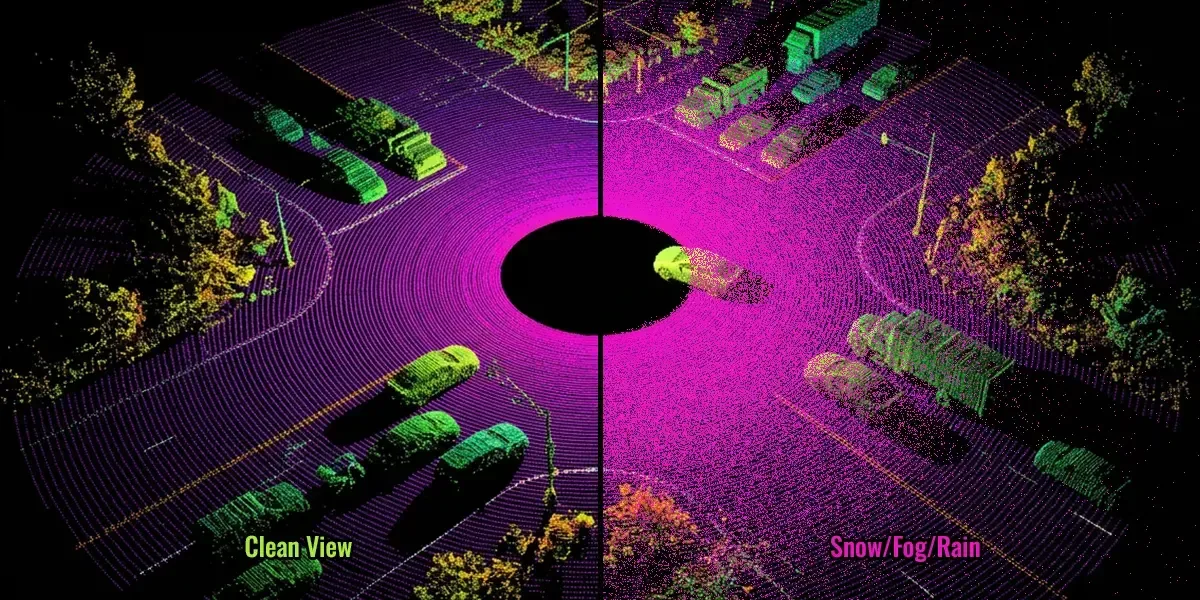
As LiDAR adoption continues to grow, maintaining reliable recognition in real-world environments remains a major challenge. Environmental factors such as rain, fog, snow, and airborne particles can cause noise, lower point density, and impact the quality of the data captured. These disturbances can make object boundaries unclear and affect segmentation performance. Despite significant advances in AI systems using LiDAR, harsh weather conditions are still a problem for the development of stable and reliable perception models.
Why Point Cloud Segmentation is Important in LiDAR Systems?
3D point cloud data describing the surrounding environment is generated in large amounts by LiDAR sensors. But without further processing, raw point clouds are not useful to AI systems. Point cloud segmentation organizes this data by separating different objects and regions in the scene, enabling perception models to better understand the environment.
Segmentation supports object detection and allows artificial intelligence systems to distinguish vehicles, pedestrians, cyclists, and other road users from background elements. It also facilitates obstacle recognition, allowing autonomous systems to identify unexpected obstacles and respond accordingly during operation.
Another important application is free space estimation. Segmentation helps determine where vehicles and robots can move safely by identifying movement areas and separating them from obstacles. Furthermore, the scene understanding is more reliable if these structures and vegetation are correctly classified from the point cloud data, as are the roads and the surrounding buildings.
Such features are required for autonomous navigation. Perception models need to accurately segment the environment to create a coherent representation of the surrounding world and to improve safer decision-making in complex environments, which can be applied in many contexts, including mobile robots and intelligent transportation systems.
How Weather Conditions Affect LiDAR Data Quality?
While LiDAR data offers spatial detail, other environmental factors can affect its performance. Laser propagation can be affected by particles and reduced visibility in the atmosphere, which can have a negative impact on the quality of the point clouds captured. Various weather conditions introduce different types of disturbances, resulting in varying weather-induced perception challenges for point cloud segmentation.
- Rain
When it rains, it can be more difficult for LiDAR sensors to obtain clear, reliable data. As rain intensity increases, water droplets interfere with the laser signal, reducing the amount of information returned to the sensor. It has been demonstrated that the maximum detection distance drops by almost 30% durng heavy rainfall at approx 45mm/h. At the same time, the number of valid point cloud returns can drop by around 45%.
Heavy rain may also affect the accuracy of what is observed around the object. Under intense precipitation above 40 mm/h, traffic signs may become difficult to detect, and distance measurements can become less stable. These changes can cause degradation in the point clouds and make segmentation of objects difficult.
- Fog
Fog is one of the most challenging weather conditions for autonomous systems due to the fact that it can significantly affect the distance of visibility. Dense fog can make it harder to see the vehicles around them, pedestrians, traffic signs, and lane boundaries. This is one reason why LiDAR has become an important sensor for autonomous navigation, as it provides 3D distance information that is completely independent of visible light.
However, fog also impacts the operation of LiDAR. Airborne laser particles can disperse and absorb some of the laser energy before reaching other objects. As a result, the reflected signal is weaker and distant objects may appear incomplete in the point cloud. Object boundaries can become unclear, making it more challenging for segmentation models to accurately separate nearby vehicles, pedestrians, and other road elements.
- Snow
Snow presents a unique challenge for autonomous systems because visibility can rapidly fall in snowy conditions. In this scenario, LiDAR can be especially useful as it offers 3D spatial data that is beneficial for identifying other vehicles, objects and road elements in areas where cameras are not visible. However, snow can also affect LiDAR performance. When snowflakes are moving, they might be captured by the sensor and will be temporary objects within the point cloud. This will create noise and make it harder to differentiate between the real structure of the environment and the snowflakes created from the weather.
To improve perception in such situations, recent research introduced LIORNet, a self-monitoring system that removes snow noise from LiDAR point clouds. The model incorporates several physical and statistical features, such as snow reflectivity, point sparsity, and limitation in sensing range, and intensity information, to separate weather-related noise from real objects. This approach also overcomes one of the major challenges associated with training perceptual models of snowy environments by eliminating the need for manually annotated snowfall datasets.
- Dust and Smoke
Dust and smoke have particles in the air that can block lasers from reaching their targets. This reduces point density and can lead to imperfect object shapes. These disturbances can create a problem in distinguishing surrounding objects during the segmentation of the images in industrial environments and construction sites.
Adverse weather conditions can cause noise, false detections, and distorted object boundaries in LiDAR data. These challenges have a direct impact on point cloud segmentation and remain a motivator for further research investigating how to enhance the reliability of autonomous perception systems in a changing environment.
The Growing Role of Multi-Sensor Fusion in Adverse Weather
Single sensors can be impacted by adverse conditions in varying ways. Therefore, the use of LiDAR in combination with other sensors has become a common approach for autonomous systems to provide reliable perception when a single sensor becomes less effective.
- Cameras: LiDAR provides accurate depth and distance measurements, and cameras provide visual information such as colors, lane markings, traffic signs, and the appearance of other objects. The combination of both sensors allows the recognition system to maintain scene understanding in the case of sensor failure due to limited point cloud density and poor image clarity.
- Radar: Radar works well in low-visibility situations such as fog, rain and snow where LiDAR and camera might not perform as well. Radar provides robust distance and velocity measurements in adverse weather, while LiDAR contributes detailed 3D spatial information. Combining both sensors improves environmental perception.
- Thermal Sensors: These sensors are used to detect heat signatures rather than visible light. By combining thermal data with LiDAR offers a way to see pedestrians, animals and other objects even when they are not visible to a conventional imaging sensor, such as a camera, due to darkness, smoke and fog.
By using multiple different sensors, recognition systems can provide additional redundancy and operate more reliably in safety-critical environments. The multisensory approach not only improves environmental awareness but also enables more stable autonomous navigation under difficult weather conditions.
Dataset and Annotation Challenges for Weather-Affected Point Clouds
The development of datasets for LiDAR point cloud segmentation is much more challenging when weather is included. Large amounts of 3D data need to be handled, and all teams using point clouds to create annotations need to consider weather-related distortions that can occur and impact the appearance of objects within the point cloud.
- Large Volumes of 3D Data: LiDAR sensors continuously produce large volumes of spatial data. Managing and annotating these datasets requires significant time and careful quality control.
- Noisy Weather Artifacts: Rain, snow, fog, and dust can cause unwanted points and false reflections. It can be difficult to annotate this unwanted noise because it can sometimes be mistaken for the environmental structures it represents.
- Occlusions: Objects may be partially obscured by surrounding vehicles, vegetation, or weather-related clutter, making it difficult to determine their boundaries.
- Labeling Consistency: Labeling consistency on large datasets is crucial. Even small labeling differences can affect model training and segmentation accuracy.
- Point-Level Segmentation Complexity: In contrast to image segmentation, LiDAR segmentation is based on individual points scattered in 3D space. This typically necessitates more complex relationships of annotation and more knowledge of spatial relationships.
Conclusion
LiDAR systems are expected to continue to play a key role in the development of autonomous vehicles, robotics, and intelligent infrastructure systems, making it increasingly important to provide reliable recognition in real-world environments. One of the main issues that affects how well an AI model understands a 3D scene is the variability of the environment. Therefore, creating robust perception systems requires not only sophisticated algorithms but also high-quality datasets that accurately reflect the conditions encountered in real-world applications.
Ongoing research, advanced sensor technologies, and well-structured annotation workflows can help address these challenges and improve the performance of LiDAR-based AI systems. As recognition requirements become more demanding, the quality of training data will continue to play a critical role in supporting more robust and adaptive autonomous applications.