

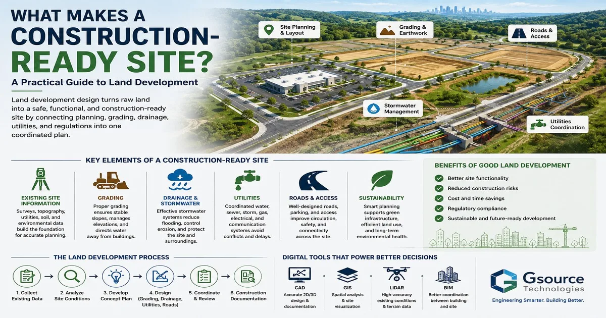
A building cannot be successful if the site beneath it is poorly planned.
Before construction begins, developers and engineering teams must answer several practical questions: Can the site support the proposed development? Where should buildings, roads, utilities, and drainage systems go? How will stormwater move through the property? Can construction equipment access the site efficiently?
These questions are addressed through land development design.
Land development is the process of evaluating and designing a property so it can be transformed into a safe, functional, and construction-ready site. It connects surveying, civil engineering, site planning, grading, drainage, utilities, transportation, and regulatory requirements into one coordinated plan.
What Makes a Site Construction-Ready?
A construction-ready site is more than an empty piece of land with enough space for a building.
It needs to work as a complete system.
Several factors determine whether a site is ready for development:
- Existing terrain and elevations
- Property boundaries
- Soil and environmental conditions
- Stormwater drainage
- Utility availability
- Road and site access
- Building locations
- Parking and circulation
- Grading requirements
- Local development regulations
If these elements are not considered early, problems can appear during construction.
For example, a building may fit comfortably on a site from a purely geometric perspective, but poor grading could create drainage problems. Similarly, a proposed road may look practical on a concept plan but become difficult to construct because of elevation changes or utility conflicts.
Good land development design considers these relationships before construction begins.
The First Step: Understanding Existing Site Conditions
Every development project starts with existing information.
Engineers and designers may need information from:
- Boundary surveys
- Topographic surveys
- Utility surveys
- Geotechnical investigations
- Environmental studies
- Aerial imagery
- GIS data
- LiDAR or reality-capture data
This information establishes what already exists on the property.
Accurate existing-condition data is particularly important because the proposed design depends on it. Incorrect elevations, missing utilities, or outdated site information can affect grading, drainage, roadway design, and building placement.
The quality of the final development plan is therefore strongly influenced by the quality of the information used at the beginning.
Why Grading Is So Important
Grading is one of the most important components of land development design.
A grading plan establishes proposed ground elevations and slopes across the site. The goal is not simply to make the land level. Instead, the terrain must be shaped to support buildings, roads, pedestrian areas, drainage systems, and surrounding properties.
Good grading can help:
- Direct stormwater away from buildings
- Create accessible routes
- Reduce unnecessary earthwork
- Support road construction
- Improve site drainage
- Connect proposed and existing elevations
Poor grading can create standing water, erosion, difficult access, and additional construction costs.
For this reason, grading should be considered together with the overall site layout rather than treated as an isolated drawing.
Stormwater Management Cannot Be an Afterthought
When a natural site is developed, changes to surfaces and drainage patterns can affect how rainwater moves across the property.
Buildings, parking areas, roads, and other improvements can change the amount and direction of runoff.
Land development teams therefore need to consider stormwater management during the early planning stages.
Depending on the project, solutions may include:
- Detention systems
- Retention systems
- Storm drainage networks
- Swales
- Infiltration systems
- Drainage channels
- Erosion-control measures
The appropriate solution depends on the site's characteristics and applicable local requirements.
The key principle is simple: stormwater should be planned as part of the site, not added after the site has already been designed.
Roads and Access Shape the Entire Development
A development also needs practical access.
Roadways, driveways, parking areas, loading zones, emergency access, sidewalks, and pedestrian routes all influence how people move through a property.
For larger developments, roadway design must also work with:
- Site grading
- Drainage
- Utilities
- Building locations
- Property boundaries
- Traffic requirements
A road network that looks efficient on a conceptual plan may require significant changes once elevation, drainage, and infrastructure constraints are considered.
Early coordination helps prevent these conflicts.
Utility Coordination Is Another Critical Element
Water, sanitary sewer, stormwater, electrical, gas, and communication infrastructure often share limited underground space.
Without proper coordination, utilities can conflict with:
- Foundations
- Roads
- Drainage systems
- Existing utilities
- Landscaping
- Other underground infrastructure
Land development design helps establish where these systems should be located and how they connect to existing infrastructure.
The earlier these relationships are considered, the fewer surprises are likely to occur during construction.
How Digital Technology Is Changing Land Development
Land development has traditionally depended on survey information, engineering calculations, drawings, and manual coordination.
Today, digital technologies are making this process more connected.
CAD
CAD remains an important tool for creating site plans, grading plans, utility layouts, roadway drawings, and construction documentation.
GIS
GIS allows project teams to analyse spatial information and understand relationships between a property and its surrounding environment.
LiDAR and Reality Capture
LiDAR and reality-capture technologies can provide detailed information about existing terrain and physical conditions.
BIM
BIM can help connect building information with site and infrastructure data, particularly on complex projects involving multiple disciplines.
The goal of these technologies is not simply to create attractive digital models. Their real value comes from helping project teams make better decisions using more reliable information.
What Happens When Site Planning Is Poor?
Many construction problems can be traced back to decisions made before construction begins.
Poor site planning can contribute to:
- Unexpected drainage problems
- Utility conflicts
- Excessive excavation
- Construction delays
- Design revisions
- Difficult site access
- Increased project costs
- Regulatory complications
Not every problem can be prevented through design, but early engineering analysis can significantly improve project predictability.
This is why land development should be viewed as a risk-management activity as much as a design activity.
How Land Development Supports Sustainable Construction
Sustainability is increasingly becoming part of site planning.
A well-planned development can consider:
- Stormwater management
- Erosion control
- Efficient land use
- Natural site features
- Green spaces
- Pedestrian connectivity
- Water management
- Material and earthwork efficiency
Sustainable development does not necessarily mean adding expensive technology to a project. Sometimes it begins with making better decisions about how the site is organised.
Using the existing terrain intelligently, minimizing unnecessary earthwork, and managing stormwater effectively can all contribute to better long-term site performance.
When Should Land Development Design Begin?
Land development design should begin during the early planning stages rather than after architectural concepts are finalized.
Early coordination allows developers to understand whether their proposed project is practical before committing significant resources to detailed design.
A typical workflow may look like this:
Existing Data → Site Analysis → Concept Planning → Grading & Drainage → Utilities & Roads → Coordination → Construction Documentation
The exact process varies by project and jurisdiction, but the principle remains the same: major site decisions should be evaluated before construction begins.
Frequently Asked Questions
What is land development design?
Land development design is the engineering and planning process used to prepare land for development. It can include site planning, grading, drainage, stormwater management, utilities, roads, access, and construction documentation.
Why is grading important?
Grading establishes proposed elevations and slopes across a site. It helps support buildings and roads while directing stormwater and improving site functionality.
What is included in a land development plan?
Depending on the project, it may include site layouts, grading, drainage, utilities, roadways, parking, stormwater systems, erosion control, and construction documentation.
How does GIS help land development?
GIS helps teams analyze and visualize spatial information such as property boundaries, terrain, infrastructure, environmental features, and surrounding development.
Can BIM be used for land development?
Yes. BIM can support coordination between buildings and site infrastructure, particularly on complex projects involving multiple engineering disciplines.
Why should developers plan drainage early?
Drainage affects grading, building locations, roads, utilities, and long-term site performance. Addressing it early can reduce the need for expensive design changes later.
The Bottom Line
A construction-ready site is created through planning, analysis, coordination, and engineering—not simply through clearing land and starting construction.
The strongest development plans bring together survey information, site layout, grading, drainage, utilities, access, environmental considerations, and regulatory requirements before construction begins.
Digital tools such as CAD, GIS, LiDAR, and BIM are making this process more efficient, but technology alone does not create a successful development. The quality of the underlying information and the decisions made from it matter just as much.
For developers and AEC professionals, the most important question is therefore not simply:
“Can we build here?”
It is:
“How can we design this site so that the entire development works together?”
That is the real purpose of land development design.
About Gsource Technologies
Gsource Technologies provides land development design, civil engineering, CAD drafting, BIM modelling, structural detailing, MEP engineering, and digital engineering support for AEC organizations.
Its land development capabilities include site planning, grading, drainage, stormwater management, utility coordination, roadway design, and construction documentation.
Organizations interested in professional Land Development Design Services can learn more at:
https://www.gsourcedata.com/civil-engineering-design-and-drafting/land-development/