
Before a shovel, drill, excavator, or boring machine enters the ground, it is important to understand what may already be there. Modern properties and infrastructure can contain layers of underground electrical cables, water lines, communication conduits, sewer systems, gas infrastructure, drainage networks, and abandoned utilities. Some may be accurately documented, while others may not appear on current records at all.
Underground utility locating helps identify and map these hidden features before construction or excavation begins. By combining technologies such as ground penetrating radar, electromagnetic locating, records research, surveying, and surface observations, professionals can develop a clearer picture of subsurface conditions and reduce uncertainty on a project site.
Why Underground Utility Locating Is Important
Underground infrastructure is often more complicated than it appears from the surface. A property may have undergone several phases of construction, with new utilities installed alongside older systems. Over time, documentation can become incomplete, and abandoned infrastructure may remain beneath roads, parking lots, buildings, and landscaped areas.
Excavating without adequate information can result in accidental utility strikes. Depending on the type of infrastructure involved, the consequences can include service interruptions, property damage, costly repairs, project delays, and serious safety risks.
Utility locating provides information that can be used during planning and before ground disturbance. It does not eliminate every risk, but it can significantly improve awareness of potential underground conflicts.
How Underground Utility Locating Works
There is no single technology that identifies every type of underground utility in every environment. Professional locating often involves multiple methods.
Electromagnetic locating is commonly used for conductive utilities and tracer wires. A signal can be introduced onto a utility and detected at the surface, allowing the approximate route of the line to be followed.
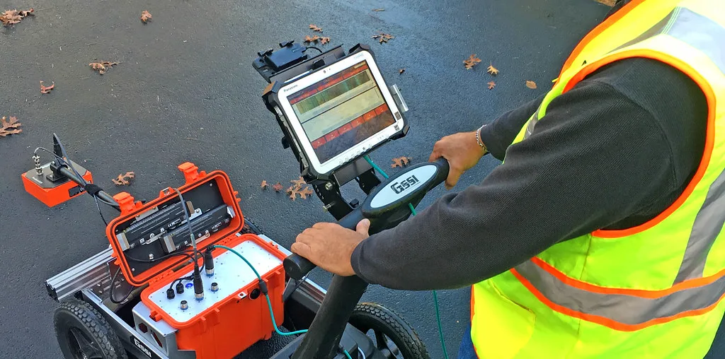
Ground penetrating radar provides another source of information. It sends electromagnetic pulses into the ground and records reflections from changes in subsurface materials. These responses can reveal potential pipes, conduits, structures, voids, and other buried features.
The two technologies can complement each other. Electromagnetic locating can provide strong information about conductive utilities, while GPR can help investigate areas where non-metallic objects or undocumented subsurface features may be present.
Ground Penetrating Radar and Utility Detection
Ground penetrating radar is particularly useful when the underground environment contains different types of infrastructure.
Unlike techniques that depend on a utility carrying an electrical signal, GPR detects contrasts in the physical and electromagnetic properties of the subsurface. Under suitable conditions, this allows it to identify features that may otherwise be difficult to trace.
A GPR antenna is moved across the survey area while collecting continuous data. Repeated passes can reveal linear patterns and other anomalies. These observations can then be positioned on a site plan or digital map.
The quality of GPR results depends on several factors, including soil composition, moisture, depth, target size, antenna frequency, and surrounding materials.
Locating Utilities Before Construction
Construction projects are one of the most common situations where underground utility locating becomes important.
Before excavation for foundations, drainage systems, trenches, roads, or other structures, project teams need to understand the existing subsurface environment. Utility locating can identify potential conflicts between planned work and existing infrastructure.
For example, a proposed foundation may cross an existing communication conduit, or a new drainage trench may run close to a water line. Discovering these conflicts during planning provides more opportunity to adjust the design or construction approach.
This can be considerably more efficient than discovering the same problem after excavation has already started.
Utility Locating in Roads and Pavements
Roads, sidewalks, parking areas, and other paved surfaces often contain dense utility networks. Water, electrical, telecommunications, drainage, and other systems may run beneath the same area.
Traditional excavation can be disruptive and expensive, particularly when investigating large paved areas. Non-destructive locating technologies allow a significant amount of information to be collected while leaving the surface intact.
GPR can be particularly useful for surveying pavement because data can be collected along planned routes or grids. The results can then be analyzed to identify potential utility corridors and other subsurface features.
Non-Metallic Utilities
One of the challenges in underground utility locating is identifying non-metallic infrastructure.
Plastic pipes, fiberglass conduits, and other non-conductive materials may not respond to electromagnetic locating methods in the same way as metallic utilities. Some systems may include tracer wires that make them easier to locate, but this is not always the case.
GPR provides a different method of investigation. Under suitable soil and site conditions, radar can identify reflections associated with non-metallic buried features.
This is one reason combining locating technologies can provide more useful information than relying on a single detection method.
Utility Locating for Drilling and Excavation
Horizontal drilling, directional boring, concrete cutting, coring, and excavation all involve different types of subsurface risk.
Before drilling or boring, contractors need to understand whether existing utilities occupy the proposed path. Similarly, concrete cutting or coring can encounter embedded conduits, reinforcing steel, or other structures that are not visible from the surface.
Utility locating can support these activities by providing information about potential obstacles and their approximate locations.
The exact locating process depends on the project, but the goal remains the same: identify relevant subsurface features before they become unexpected obstacles.
What Happens During a Utility Survey?
A professional survey generally begins with gathering available information about the site. Existing utility records, drawings, previous survey information, and visible infrastructure can provide useful context.
The survey area is then examined using appropriate locating technologies. Technicians may scan in multiple directions or establish a grid to understand how detected features continue across the site.
Positioning equipment can be used to record the location of detected features. The collected information may eventually be presented as marked-up drawings, CAD information, GIS data, digital maps, or other project documentation.
The final result depends on the project's requirements and the level of detail needed.
Challenges That Can Affect Utility Locating
Underground utility locating is not an exact science in every environment. Soil conditions, target depth, utility material, interference, surface conditions, and incomplete records can all affect detection.
Highly conductive soils can limit GPR penetration. Congested utility corridors can also make individual features difficult to distinguish. Older or abandoned infrastructure may create additional ambiguity.
For this reason, detected features should be interpreted within the context of the entire site. Combining records, electromagnetic locating, GPR, surveying, and other available evidence can provide a more complete understanding.
From Utility Detection to Utility Mapping
Locating a utility and mapping a utility network are related but different tasks. Locating focuses on determining where a particular feature may be found. Mapping takes that information and organizes it spatially across the project area.
Digital mapping has become increasingly valuable for complex projects. Underground features can be represented alongside buildings, property boundaries, roads, proposed construction, and other site information.
This creates a shared reference that engineers, contractors, surveyors, utility owners, and project managers can use when coordinating work.
A More Informed Approach to Underground Construction
Underground utility locating plays an important role in modern construction and infrastructure planning. The technology helps project teams investigate hidden conditions before excavation and identify potential conflicts that may not be visible from the surface.
GPR, electromagnetic locating, positioning systems, existing records, and professional interpretation each provide different pieces of information. Used together, they can create a more detailed understanding of the underground environment.
The objective is not simply to find pipes and cables. It is to reduce uncertainty, improve project planning, and give construction teams better information before they disturb the ground.