If you are planning a journey to the sacred shrine of Kedarnath Temple, one question naturally comes first what is the Gaurikund to Kedarnath trek distance?
The answer is simple and official. The trekking route from Gaurikund to Kedarnath is approximately 16 kilometers. This is the government-approved and currently operational trekking route maintained by the authorities in Uttarakhand.
But distance alone does not tell the full story.
This trek is not just about numbers. It is about altitude, terrain, weather, preparation, and faith. In this detailed guide, we will break down everything you need to know with verified facts, practical logic, and zero exaggeration.
Official Gaurikund to Kedarnath Trek Distance
The current trekking distance from Gaurikund to Kedarnath is around 16 km.
After the 2013 floods in Uttarakhand, authorities redesigned the old 14 km route to make it safer and more structured. The new path is slightly longer but significantly more secure.
The trek usually takes:
- 6 to 8 hours for physically fit trekkers
- 8 to 10 hours for average pilgrims
- More time if you walk slowly or take frequent breaks
Distance may look manageable on paper. However, this is a continuous uphill climb in high-altitude terrain.
Altitude Difference: Why 16 km Feels Longer
Here is an important fact most people ignore.
- Gaurikund altitude: approx. 1,982 meters
- Kedarnath altitude: approx. 3,583 meters
That means you gain nearly 1,600 meters in elevation within 16 kilometers.
This steady climb makes the trek demanding. The oxygen level drops as you go higher, and the air feels thinner near Kedarnath.
According to high-altitude health guidelines issued by mountaineering and medical bodies, gradual ascent helps reduce fatigue and altitude discomfort. So walking at a steady pace makes sense racing uphill does not.
Route Breakdown: Major Points on the Trek
The kedarnath trekking route includes several important stops. These points help pilgrims rest, hydrate, and reorganize.
Key stops include:
- Jungle Chatti
- Bheembali
- Linchauli
- Base Camp
- Kedarnath Temple
The Uttarakhand government has developed proper shelters, medical aid centers, food stalls, and resting spots along the way.
After the 2013 disaster, authorities improved the route with better safety measures. According to reports by the National Disaster Management Authority, improved planning and structured routes reduce risk during extreme weather.
Trek Difficulty Level
Let’s keep it honest.
This trek is moderate to challenging.
It is not a casual evening walk. You climb continuously. The path includes:
- Steep gradients
- Rocky sections
- High-altitude exposure
- Sudden weather changes
However, thousands of pilgrims of all age groups complete this trek every year.
If senior citizens with determination can reach Kedarnath, a well-prepared adult can absolutely manage it.
Preparation makes the difference.
Best Time to Do the Trek
The temple generally opens in April or May and closes around October or November, depending on weather conditions.
The best months for trekking are:
- May to June
- September to October
During monsoon months like July and August, heavy rainfall increases the risk of landslides in the Himalayan region. The India Meteorological Department regularly issues weather updates for Uttarakhand. Always check forecasts before travel.
Avoid assuming that clear skies in the morning guarantee good weather all day. Mountain weather changes quickly.
Facilities Available on the Trek
The government and local authorities maintain facilities to ensure pilgrim safety.
You will find:
- Drinking water points
- Basic medical facilities
- Rest shelters
- Food stalls
- Pony and palki services
- Helicopter service options
Helicopter services operate from nearby helipads like Phata, Sersi, and Guptkashi, subject to weather clearance.
Many pilgrims now compare trekking with aerial options. However, if you want the traditional spiritual experience, walking the 16 km route remains the most meaningful choice.
Pony, Palki, and Other Options
Not everyone wants to walk 16 kilometers uphill. That is understandable.
You can choose:
- Pony services
- Palki (palanquin)
- Pitthu (porter carrying luggage or child)
These services operate under regulated pricing controlled by local authorities.
If you have knee issues, breathing problems, or are traveling with elderly family members, these alternatives help you complete the pilgrimage safely.
Health and Fitness Tips for the Trek
Now let’s talk practical logic.
You do not need to be an athlete. But you should prepare your body.
Start light cardio exercises at least 2 to 3 weeks before the trek. Walking 4 to 5 kilometers daily improves stamina.
Carry:
- Good trekking shoes
- Rain protection
- Warm layers
- Water bottle
- Basic medicines
High altitude affects each person differently. If you feel dizziness, breathlessness, or unusual fatigue, consult the medical aid posts immediately.
Faith is powerful. But oxygen levels still matter.
Registration and Guidelines
Pilgrims must complete registration before undertaking the Char Dham Yatra, including Kedarnath.
The Uttarakhand Tourism Development Board manages official registration and updates.
Authorities introduced mandatory biometric registration to enhance safety tracking. This system helps monitor pilgrim movement and improves emergency response efficiency.
Always use official government portals for updates. Avoid relying on random social media posts.
Why the Trek Still Attracts Millions
Despite the challenging climb, millions visit Kedarnath every year.
Why?
Because this is not just a trek.
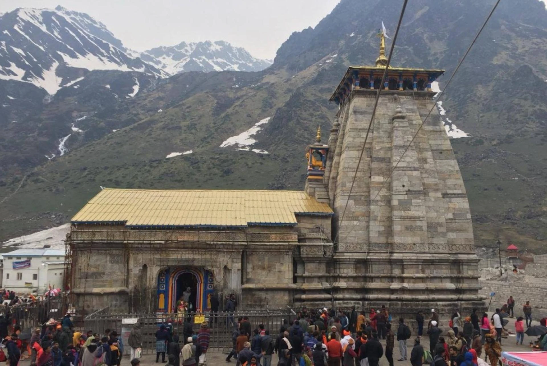
It is one of the holiest shrines dedicated to Lord Shiva and part of the sacred Char Dham circuit in Uttarakhand.
The temple stands against the dramatic backdrop of snow-covered Himalayan peaks. The spiritual atmosphere feels powerful and peaceful at the same time.
You feel tired while walking. But once you see the temple structure appear in the valley, the fatigue suddenly feels smaller.
That moment alone explains why people willingly walk 16 kilometers uphill.
Safety After the 2013 Floods
The 2013 floods severely impacted the Kedarnath region. After that disaster, authorities redesigned infrastructure and strengthened safety systems.
The new trekking route avoids vulnerable sections of the older path.
According to government recovery reports, improved slope stabilization and structured paths have reduced landslide risks compared to the earlier route.
However, Himalayan terrain always demands caution. Respect the mountains. Follow instructions from local authorities.
Frequently Asked Questions
Is the Gaurikund to Kedarnath trek exactly 16 km?
Yes. The currently operational trekking route measures approximately 16 kilometers.
Can beginners complete this trek?
Yes, if they prepare physically and walk at a steady pace.
Is it safe for senior citizens?
Many senior citizens complete the trek every year. However, medical fitness and doctor consultation remain important.
How long does it take?
Most pilgrims take between 6 to 10 hours depending on pace and fitness level.
Final Thoughts
The Gaurikund to Kedarnath trek distance may be 16 kilometers on paper, but the journey offers much more than physical movement.
It tests endurance.
It builds patience.
It strengthens faith.
Prepare properly. Check official updates. Respect the mountain environment.
When you finally stand in front of Kedarnath Temple after walking those 16 kilometers, you will understand something simple some journeys are meant to be walked, not measured.
And that is the real distance that matters.