Antique world maps hold a unique charm that blends history, geography, art, and imagination into a single masterpiece. Long before digital navigation and satellite imagery transformed our understanding of the planet, cartographers relied on exploration reports, astronomical observations, and educated guesses to create representations of the world. These early maps not only documented geographical knowledge but also reflected the cultural, political, and scientific mindset of their era.
Collectors, historians, and art lovers are drawn to antique world maps because they serve as tangible links to humanity’s evolving perception of the Earth. Each map tells a story of discovery, ambition, trade, conquest, and creativity.
The Origins of World Mapping
The history of world maps dates back to ancient civilizations. Early attempts to represent the world can be traced to ancient Mesopotamia, Greece, and Rome. One of the most influential early geographers was Claudius Ptolemy, whose work "Geographia" laid the foundation for Western cartography. His system of latitude and longitude became a cornerstone for future mapmakers.
During the Middle Ages, European maps often combined religious symbolism with geographical knowledge. These medieval maps, sometimes called “T-O maps,” placed Jerusalem at the center of the world and emphasized spiritual understanding over accurate scale.
As exploration expanded in the 15th and 16th centuries, mapping entered a golden age. Explorers like Christopher Columbus and Ferdinand Magellan brought back information that reshaped global geography. Cartographers rapidly updated their maps to reflect newly discovered lands across the Atlantic and Pacific Oceans.
The Golden Age of Cartography
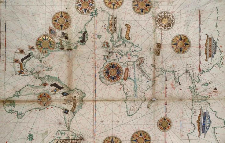
The 16th and 17th centuries are often referred to as the Golden Age of Cartography, particularly in the Netherlands. This period saw the rise of master mapmakers whose works are now highly prized as antique treasures.
One of the most renowned figures was Gerardus Mercator, creator of the Mercator projection. His projection revolutionized navigation by allowing sailors to plot straight-line courses across the seas. Although it distorted the size of landmasses near the poles, it became one of the most influential map projections in history.
Another legendary cartographer was Abraham Ortelius, who published one of the first modern atlases, "Theatrum Orbis Terrarum." His world maps combined artistic beauty with geographical detail, setting a high standard for printed cartography.
These antique maps were often hand-colored and richly decorated with elaborate cartouches, sea monsters, sailing ships, and compass roses. They were as much works of art as they were navigational tools.
Artistic Beauty and Symbolism
One of the defining features of antique world maps is their extraordinary artistic detail. Unlike modern maps designed primarily for functionality, antique maps often featured decorative borders, mythological creatures, allegorical figures, and elaborate typography.
Sea monsters symbolized the unknown dangers of unexplored waters. Wind heads blowing across the oceans illustrated prevailing winds. Ornate title cartouches framed the map’s name in dramatic fashion. These artistic elements transformed maps into storytelling canvases.
The colors used in antique maps were typically applied by hand using watercolor. Even printed maps varied in appearance because colorists interpreted designs individually. This individuality adds to their charm and uniqueness.
Reflection of Political and Cultural Perspectives
Antique world maps also reveal the political ambitions and cultural biases of their creators. As empires expanded, maps emphasized territorial claims and colonial possessions. European powers such as Spain, Portugal, England, and France used maps as tools of influence and propaganda.
For example, during the Age of Exploration, European cartographers often centered the map on Europe, reinforcing its perceived importance. Newly discovered lands were sometimes labeled with European names, reflecting the era’s colonial mindset.
Maps also contained inaccuracies that reflected limited knowledge. California was famously depicted as an island on several 17th-century maps due to early misconceptions. These errors, rather than diminishing value, often enhance a map’s historical significance and collector appeal.
Printing Techniques and Materials
Antique world maps were typically produced using engraving techniques. Copperplate engraving became popular during the Renaissance, allowing for intricate detail and mass production. The engraved plate was inked and pressed onto paper, creating crisp lines that could be hand-colored afterward.
The paper used in antique maps was often handmade from linen rags, resulting in durable sheets that have survived centuries. Over time, these maps develop a warm patina that enhances their visual appeal.
Some world maps were included in atlases, while others were produced as standalone wall maps. Large wall maps were sometimes mounted on linen for durability and display in libraries, universities, and wealthy households.
The Role of Exploration and Scientific Advancement
Antique world maps document humanity’s growing scientific understanding of the planet. As explorers charted coastlines and measured latitudes, maps became increasingly accurate. The invention of better navigational instruments, such as the marine chronometer, improved longitude calculation.
By the 18th century, global mapping had become more precise. Expeditions sponsored by governments and scientific societies filled in blank spaces on earlier maps. The Pacific Ocean, Africa’s interior, and the polar regions gradually became better understood.
However, even as accuracy improved, antique maps retained artistic flourishes that reflected their heritage. The blend of science and art is what makes these maps so captivating today.
Why Collectors Value Antique World Maps
Collectors are drawn to antique world maps for several reasons. Historical importance plays a major role. Maps from significant eras, such as the Age of Discovery, are especially desirable. Rarity also affects value. Limited print runs, condition, and originality determine market price.
Artistic beauty enhances appeal. Hand-colored maps with decorative elements often command higher prices. Provenance, or documented ownership history, can further increase value.
Antique maps are also appreciated as investment pieces. Over time, well-preserved maps by prominent cartographers tend to appreciate in value. They are frequently displayed in homes, offices, libraries, and galleries as elegant conversation pieces.
Preservation and Care
Owning an antique world map requires proper care. Exposure to direct sunlight can fade colors and weaken paper. Humidity and temperature fluctuations can cause warping or mold growth. Professional framing with archival materials helps preserve the map’s integrity.
Collectors are advised to avoid trimming margins or altering the map in any way. Restoration should only be performed by trained conservators who specialize in historical paper materials.
With careful preservation, antique maps can remain vibrant and intact for centuries, continuing to inspire future generations.
The Emotional and Educational Impact
Beyond their monetary and artistic value, antique world maps offer emotional and educational significance. They provide a window into how earlier generations understood the world. Looking at a centuries-old map allows us to appreciate the courage of explorers who ventured into unknown territories.
Students and historians use antique maps to study geopolitical changes, trade routes, and shifting borders. These maps visually illustrate the evolution of continents, empires, and civilizations.
They also remind us that knowledge is always evolving. What was once considered accurate may later be revised. Antique world maps capture moments in time when the world was still being discovered and defined.
Modern Appreciation in a Digital Age
In today’s digital era, where GPS and interactive maps are instantly accessible, antique world maps offer a refreshing contrast. Their tactile quality, handcrafted details, and historical authenticity cannot be replicated by screens.
Interior designers increasingly incorporate antique maps into décor, blending vintage elegance with contemporary style. Reproductions are popular, but original antique maps hold unmatched authenticity and character.
Museums and galleries worldwide exhibit historic maps as both artistic masterpieces and historical documents. Their ability to bridge science, art, and history ensures enduring fascination.
Conclusion: A Lasting Legacy of Exploration and Art
Antique world maps are far more than geographical references. They are historical artifacts that reflect centuries of exploration, ambition, creativity, and discovery. From the pioneering work of early geographers to the masterful engravings of Renaissance cartographers, each map captures a snapshot of humanity’s expanding knowledge.
Their artistic elegance, historical depth, and cultural symbolism continue to captivate collectors and scholars alike. In a world defined by digital precision, antique world maps remind us of a time when imagination and exploration shaped our understanding of the planet.