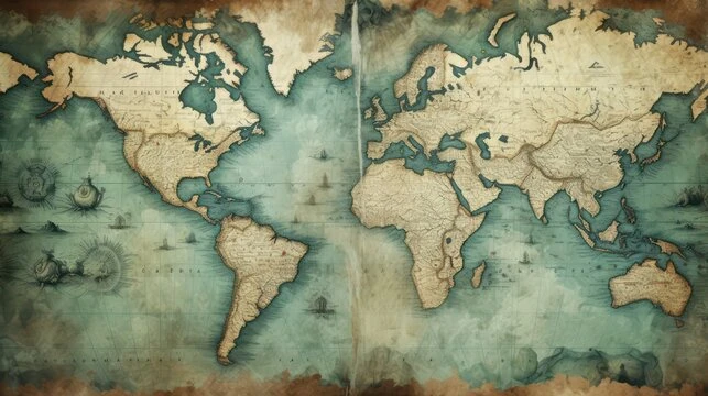
Antique world maps are more than just navigational tools; they are windows into the past, reflecting the knowledge, artistry, and cultural perspectives of their time. Each map tells a story of exploration, conquest, trade, and curiosity, capturing humanity’s evolving understanding of the world. Collectors and history enthusiasts often seek these treasures not only for their aesthetic appeal but also for the historical insights they offer. From the earliest cartographic attempts to the beautifully illustrated maps of the 17th and 18th centuries, antique maps are a bridge between geography and history.
The Origins of World Mapping
The concept of mapping the world dates back thousands of years. Ancient civilizations like the Babylonians, Egyptians, and Greeks made some of the earliest known maps. These early depictions were rudimentary and often symbolic rather than precise. They reflected a worldview shaped by mythology, religion, and limited geographic knowledge.
The Greeks, particularly figures like Ptolemy in the 2nd century, advanced the science of cartography by attempting to mathematically represent the world. Ptolemy’s “Geographia” introduced the use of latitude and longitude, a system that became the foundation for modern mapmaking. Although early maps were often inaccurate by today’s standards, they reveal the human desire to comprehend and document the world around them.
The Golden Age of Mapmaking
The 15th and 16th centuries are often referred to as the Golden Age of mapmaking. This era coincided with the Age of Discovery, during which European explorers like Christopher Columbus, Ferdinand Magellan, and Vasco da Gama expanded the known world. Cartographers worked to incorporate new discoveries into their maps, creating increasingly detailed and accurate representations of continents and seas.
During this period, maps began to be appreciated as works of art. Richly colored and intricately detailed, they often featured elaborate borders, sea monsters, and depictions of mythological figures. Maps from this era were not just practical tools; they were status symbols for wealthy patrons and explorers, signifying knowledge and power.
Styles and Techniques in Antique Maps
Antique world maps come in a variety of styles and techniques, each reflecting the artistic and technological trends of its time. Woodcut and copperplate engraving were common methods used in the production of maps before the advent of modern printing techniques. These methods allowed for detailed line work and intricate illustrations, making maps visually striking.
Hand-coloring was another technique that enhanced the aesthetic value of antique maps. Color was often added to highlight borders, trade routes, or specific regions. Some maps were adorned with gold leaf or delicate watercolor, making them even more visually appealing. Collectors often seek maps with original hand coloring, as it adds uniqueness and historical authenticity.
Notable Antique World Maps
Several antique world maps are particularly famous for their historical and artistic significance. The Waldseemüller map of 1507, for example, is credited with being the first map to use the name “America” to designate the newly discovered continents. Its depiction of the world was groundbreaking at the time and influenced subsequent cartography.
Another notable example is the maps of Gerardus Mercator, whose 1569 world map introduced the Mercator projection, a method that represented lines of constant compass bearing as straight lines. This projection revolutionized navigation and is still used in modern mapping. Maps by Abraham Ortelius, the creator of the first modern atlas, are also highly prized for their precision and elegant design. Each of these maps tells a story about exploration, scientific advancement, and the changing understanding of the globe.
The Role of Cartography in History
Antique world maps are more than decorative artifacts; they provide valuable insights into historical events, trade routes, and cultural perspectives. For example, maps produced during the colonial era often reveal how European powers viewed foreign lands and peoples. The exaggeration of certain territories, omission of others, and the inclusion of fantastical creatures reflect the beliefs and biases of the mapmakers.
Maps were also crucial for economic and political purposes. Accurate maps allowed traders to navigate new trade routes, helped military leaders plan campaigns, and enabled governments to assert control over distant territories. As such, antique maps are not only artistic masterpieces but also historical documents that reveal the geopolitical realities of their time.
Collecting Antique World Maps
Collecting antique world maps is a pursuit that combines historical interest with aesthetic appreciation. Enthusiasts seek maps based on age, rarity, condition, and historical significance. Some collectors focus on maps from a particular era, such as the 16th-century Age of Discovery, while others prefer maps that showcase specific regions or cartographic techniques.
Condition is a critical factor in determining the value of an antique map. Well-preserved maps with minimal damage, vibrant coloring, and clear inscriptions are highly prized. Maps that have been expertly restored or that retain their original features often command higher prices. Provenance, or the documented history of a map’s ownership, can also enhance its value by providing a connection to historical events or notable figures.
Antique Maps as Art and Decoration
Beyond their historical significance, antique world maps are widely appreciated for their artistic beauty. Many maps feature elaborate illustrations of flora, fauna, and human figures, blending geographic accuracy with artistic expression. The decorative borders, compass roses, and cartouches found on many maps make them visually stunning additions to any collection or interior space.
Interior designers and collectors often use antique maps as focal points in homes or offices, framing them to create a sense of sophistication and timelessness. Maps can also be used to inspire travel, spark curiosity, and serve as conversation starters, making them versatile pieces of both art and history.
The Market for Antique Maps
The market for antique world maps is dynamic and can vary significantly based on trends, rarity, and historical importance. High-profile auctions, antique shops, and specialized dealers are common sources for collectors. Prices can range from a few hundred dollars for less rare maps to millions for historically significant or exceptionally rare pieces.
The digital era has also transformed the market, allowing collectors to browse and purchase maps online. High-resolution images, detailed descriptions, and expert appraisals make it easier than ever to acquire antique maps from around the world. However, buyers must exercise caution, as reproductions and forgeries are prevalent. Expertise in identifying authentic maps, understanding paper types, ink, and cartographic styles is essential for serious collectors.
Preserving Antique Maps
Preserving antique maps requires careful attention to environmental conditions and handling. Maps are susceptible to damage from light, humidity, temperature fluctuations, and physical contact. Proper storage, such as acid-free folders, archival-quality framing, and controlled display conditions, is critical to maintain their condition.
Restoration is another important aspect of preservation. Professional conservators can repair tears, stabilize fragile paper, and clean dirt or stains without compromising the map’s historical integrity. Collectors are often advised to seek expert guidance to ensure that restoration enhances rather than diminishes the map’s value.
Educational and Research Value
Antique world maps are invaluable tools for education and research. Historians, geographers, and scholars study maps to gain insights into historical geography, exploration patterns, and cultural perceptions. By comparing maps from different periods, researchers can trace the evolution of geographic knowledge, trade networks, and political boundaries.
Museums and academic institutions often use antique maps in exhibits to illustrate the progression of human understanding of the world. These maps also serve as resources for students, allowing them to explore history visually and connect with the experiences of people from centuries past.
Conclusion
Antique world maps are more than just relics; they are living testimonies of human curiosity, exploration, and creativity. They combine artistry with science, offering a glimpse into how our ancestors viewed the world and sought to navigate it. From the intricate engravings of the 16th century to the decorative illustrations of the 18th century, each map is a unique artifact that bridges past and present.
Whether appreciated for their historical significance, aesthetic appeal, or educational value, antique maps continue to captivate collectors, historians, and enthusiasts worldwide. Owning or studying these maps is a way to connect with the adventurous spirit of earlier generations, celebrating their achievements and preserving their legacy for future generations. In a world increasingly dominated by digital maps and GPS technology, antique world maps remind us of the beauty and complexity of exploring the unknown.