Like any other developing country, Australia is also experiencing rapid growth. To sustain cities and communities, new roads, railways, bridges, and utilities are built every year. Accurate planning and reliable data are the key to making an infrastructure project successful. This is why civil infrastructure surveying becomes more critical.
Surveying helps working units better understand the land, measure distances precisely, and complete projects on time. Projects may face delays and high costs without proper surveying.
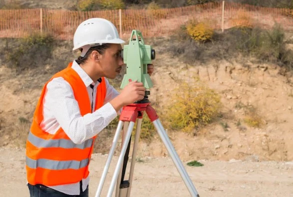
2Survey plays an essential role in supporting Australia’s infrastructure sector. The company delivers accurate surveying solutions that help the project move forward, supported by skilled professionals and modern technology.
What is Civil Infrastructure Surveying?
Civil infrastructure surveying means the proper measuring and mapping of large-scale construction projects. The survey is helpful in projects such as highways, rail corridors, bridges, tunnels and utility networks. Surveyors use the collected data to guide designers, engineers and construction teams.
Reliable civil structure infrastructure surveying ensures that the correct placement at the right level and guarantees the long-term performance of assets. It also helps teams understand the site surroundings even before the construction begins. This improves on-site safety and reduces unexpected problems.
A survey is not just a one-time job. It happens again and again throughout the project to check the progress and accuracy.
The Role of Surveying in the Infrastructure Project
Surveying supports infrastructure projects from start to finish, i.e., from design to delivery. Accurate data plans the next step. These include network control, construction set-out surveys, data management and verification. Stages of survey include;
Planning and designing
Early surveying helps to study the construction better. Surveyors collect proper measurements and landscape data. This data allows engineers to plan accurately according to real site conditions.
Construction Stage
After planning and design, surveyors mark the positions for columns and structures. Civil infrastructure surveying occurs mostly at this stage, as it is necessary to check progress periodically and ensure that construction follows approved designs.
Completion Stage
When the construction is done and the site is ready, surveyors prepare as-built records. These records show the final position of structures. This is important for future references and records. As you see, by supporting every stage, surveying reduces errors and keeps projects on track.
Survey Management & Data Accuracy at Scale
It may be challenging sometimes to manage survey data for large infrastructure projects. Multiple teams of engineers and designers rely on precise and up-to-date information. Survey data collection and management help organize data. The following are also types of survey management;
- Coordinating surveyed data and activities across teams.
- Checking data accuracy and consistency
- Delivering precise and reliable reports.
Adequate data management reduces confusion between teams and helps them to work together productively.
Why are Engineering Surveying Services Critical for Major Projects?
Modern infrastructure requires modern technology. Engineering surveyors focus on detailed measurements needed for construction accuracy. These services also include;
- Setting up control points over larger sites
- Accurate set-out of structures and services
- Frequently monitoring movements and deformation
- Checking alignment and levels during construction.
Engineering surveying services help prevent costly mistakes. Even minor errors can cause significant problems on large projects. Experienced surveyors ensure that work meets Australian standards and project requirements.
Advanced Survey Technology Powering Modern Infrastructure
Modern infrastructure projects rely on advanced technology to improve accuracy and efficiency. 2Survey uses a range of contemporary tools to deliver dependable results. Key Technologies Used;
Technologies and Their Uses:
- UAV and Drone Surveys
- To capture aerial images and site data
- Laser Scanning
- To create detailed 3D models of sites
- GPS and GNSS Systems
- Provides high-accuracy positioning
- Digital Data Workflows
- Improves data sharing and coordination
These tools allow surveyors to collect large amounts of data safely and efficiently. The technology they use also helps teams make better decisions throughout construction.
Trusted Surveyors for Infrastructure Projects Across Australia
Infrastructure projects require experienced professionals who understand local conditions and regulations. 2Survey supports civil, rail, commercial, and industrial developments nationwide as trusted surveyors for infrastructure projects in Australia.
The team understands Australian standards and site safety requirements. Their experience with large and complex projects allows them to deliver consistent results. Reliable surveying builds trust and helps projects run smoothly.
Why Choose 2Survey for Civil Infrastructure Surveying?
2Survey is trusted by contractors and project teams across Australia. The company combines experience, technology, and professional expertise to provide trustworthy surveying solutions. Below are some key reasons clients choose 2Survey, which include:
- Proven experience on major infrastructure projects
- Skilled and qualified survey professionals
- Advanced technology and modern workflows
- End-to-end surveying and data management support
2Survey helps clients complete projects safely and efficiently by focusing on accuracy and collaboration.
What is the Future of Surveying Civil Infrastructure?
The future of surveying civil infrastructure in Australia is promising. As the technology grows, the coming tools work more precisely through emerging technologies. The future will include technology such as AI-driven analytics, LiDAR-equipped drones, and real-time BIM (Building Information Modeling) platforms.
Autonomous robots and machine learning will systemize data processing and improve predictive maintenance for large-scale projects. Integration with IoT sensors aids continuous monitoring.
2Survey all set to lead by embracing these innovations to ensure Australia’s infrastructure remains future-proof.
Partnering for Infrastructure Success
As you have read above, civil infrastructure surveying is essential for the modern structural environment. Accurate data backs better planning, smoother construction, and long-term performance. 2Survey delivers Australia’s most important projects with expert engineering surveying services and advanced technology.
Teams seeking trusted surveyors for infrastructure projects Australia-wide can rely on 2Survey for the experience and precision needed for success. Partnering with the right surveying experts helps turn complex projects into lasting infrastructure solutions.
Visit our official site once to explore more of our services!
FAQs
What is civil infrastructure surveying?
It involves measuring and mapping large-scale projects like highways, bridges, and utilities. It provides accurate data for design, construction, and verification, which ensures safety and efficiency.
Why is surveying essential throughout a project?
Surveying means overseeing every stage of a project, from planning to completion. It is meant to check progress over time and minimize errors, delays and costs as well
What technologies does 2Survey use?
2Survey has UAV/drone surveys for aerial data, laser scanning for 3D models and GPS/GNSS for positioning. They also incorporate digital workflows for data sharing and coordination.
What stages of infrastructure projects require surveying?
Planning and designing for site data, construction for set-outs and monitoring, and completion for records to track progress and ensure compliance with designs.
Why choose engineering surveying services?
They provide precise control points, structure set-outs, deformation monitoring, and level checks, preventing costly errors and meeting Australian standards on major projects.