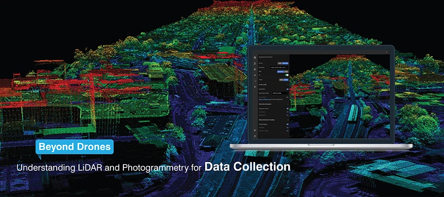
LiDAR and photogrammetry are both popular mapping technologies for surveyors. LiDAR is best suited for accuracy as well as terrain modeling, while photogrammetry provides high-resolution visual data and is cost effective. Understanding the difference in their limitations and applications helps you choose the right method for precise and efficient mapping.
Which mapping method to use: Photogrammetry vs LiDAR? Well, these two are common 3D mapping technologies that are used to create 3D maps. But they both differ: they collect data in different ways.
Both these technologies have revolutionized how experts collect, examine and analyse the spatial data. Well, in this article, we will take a detailed look at these technologies and help you choose.
What is LiDAR
Light Detection and Ranging (LiDAR) is a remote sensing technique that uses laser pulses to measure distances.
Working of LiDAR technology
Light Detection and Ranging (LiDAR) operates as a radar system that uses laser technology instead of radio waves for its operations. The device generates a laser beam that hits a designated target area.
The LiDAR system contains sensors that detect the laser beam that reflects to its starting point. The device measures the duration that the laser beam took to complete its journey. The LiDAR instruments perform this process one million times to create a detailed 3D point cloud map of the surveyed area.
LiDAR applications
- LiDAR is used in topographic surveys.
- It is widely used in area mapping for road and railway construction.
- It is the preferred choice for vegetation penetration mapping.
- It is used in scanning of large structures.
Key advantages of LiDAR
LiDAR gives consistent results that are on par with engineering standards. It is best in areas where there are lots of vegetation, complexity and concealed elements in structures. You get accurate data that has been tested and is accepted in design, analysis, and BIM workflows.
Limitations of LiDAR
The cost of LiDAR equipment is high. The level of visual detail is low, but it is improved when the RGB points are superimposed on photographs.
Therefore, if visuals are a preference for your projects rather than precision, then LiDAR could be more than what you need.
What is Photogrammetry?
In simple words, photogrammetry is measuring things from photos. Well, photogrammetry uses photographs and not lasers when recreating space.
How Photogrammetry technology operates
High-resolution cameras are fitted on drones that take overlapping images from different angles. The software, through photogrammetric triangulation, finds the common reference points and creates a 3D model.
So, lighting and visibility are very important for photogrammetry. In another case, the results will not be precise at all.
Best application fields of Photogrammetry
Photogrammetry is an absolute necessity in cases where images are critically needed, e.g., monitoring of construction sites, urban modeling, architectural surveys, and calculating volumes of mines.
Limitations of Photogrammetry
There are a few limitations of using photogrammetry:
- Photogrammetry cannot penetrate the forest.
- It has difficulty in areas where the light is poor.
- The image quality and site conditions dictate the accuracy of the technique.
In case the precision decides the outcome, this will pose a risk.
LiDAR vs Photogrammetry: Understanding the differences
Let’s take a look at how LiDAR technology differs from Photogrammetry technology:
Accuracy and precision
If you are looking for better accuracy, then you should opt for LiDAR. You will get reliable data and consistent results. Also, the result will not be affected due to shadows, lighting conditions, weather clarity, etc.
Cost and practical reality
LiDAR costs more than photogrammetry. But LiDAR provides precise data. However, photogrammetry is the ideal choice if the project has a limited budget and extremely high accuracy is not required.
Terrain and vegetation
LiDAR has the ability to map the ground under trees and in a dense canopy. Photogrammetry catches only what is in front of the camera.
In the event that the terrain is of importance, LiDAR is definitely the more secure option.
Data outputs: Point Cloud vs photorealistic 3D models
The output from LiDAR is a point cloud, which is structured and accurate in relation to structural geometry representation, and has established methods for modeling and measuring. On the contrary, photogrammetry provides greater convenience, but the data needs high processing before being used in designs.
Remote sensing techniques and conditions
LiDAR is able to generate data even in a low-light environment. Photogrammetry is possible only in the sunlight and stable weather conditions.
That one difference could completely change the way and when to do things, as well as the level of risk involved.
When LiDAR is the right call
Go for LiDAR when precision is the determining factor for the results, such as for classical infrastructure projects, areas with lots of trees, monitoring of ground movement, and places where safety is a critical factor.
When Photogrammetry makes more sense
Photogrammetry is an appropriate technique where accuracy is of less importance, and the concern is more for speed, costs, and image clarity. This covers the aforementioned activities and site documentation fast.
Combining LiDAR and Photogrammetry
LiDAR and Photogrammetry can be combined. LiDAR captures the exact shape of a place. Photogrammetry adds colour and visual details. When they are used together, they make it easy to understand the maps.
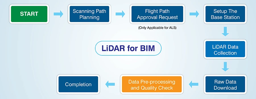
Point Cloud to BIM: Turning data into real value
Turning scan data into BIM
LiDAR and photogrammetry can both generate point clouds. However, that information is only of value when it is converted to BIM. Point cloud to BIM usually means dealing with the raw data and removing unwanted noise, and creating accurate models.
LiDAR is preferred for BIM projects as it works best for complex MEP systems, existing infrastructure, and uneven spaces.
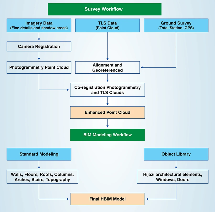
How TrueCADD helps in Point Cloud to BIM
TrueCADD helps convert raw scan data into reliable BIM models by converting point clouds and performing quality checks on these models to make sure that they are accurate and aligned for application purposes.
Final thoughts
The selection between LiDAR vs photogrammetry requires organizations to make decisions that combine technical requirements with business needs. It is best to make your choice based on the level of accuracy required, site condition, and final data usage. With the right approach and the right partner, both LiDAR and photogrammetry can deliver results you can trust.
The team at TrueCADD will help you pick software that meets your requirements, do point cloud to BIM conversion, and all design and drafting for your upcoming BIM or mapping project.