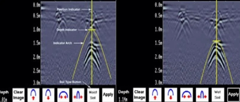
Everything You Need To Know About GPR
Ground penetrating radar is a non-invasive survey method where radio waves are used to find out the objects laid down in the ground. GPR is used to detect the location of underground utilities without damaging the ground. House owners and contractors use these services to map out the location of utilities before starting any digging process. This method helps the construction team to avoid getting any serious injury by damaging any utility. Moreover, the investigator uses ground penetrating radar to find out the exact location and line whether the utilities are laid down and provide the proper chart of infrastructure spread under the ground. Utility locators require technology such as ground penetrating radar to map out all the pipes, telephone cables, and other underground pipelines. It helps you to protect the delicate wiring underground and helps you avoid any costly mistakes while doing excavation.
What Are The Different Components Of GPR?
A typical ground penetrating radar consists of three components that help the device detect underground utilities accurately. These components make the GPR the most effective and different from other devices.
- The Control Unit
The control unit is responsible for triggering the pulse of radar energy that will be sent into the ground with the help of an antenna. The control unit of GPR contains an inbuilt camera with a hard disk and storage that allow the device to examine the field at once easily. The system can collect and process the data.
- The Antenna
The antennas are like the communication hub between the control unit and the object used in mapping the surface. The antenna is used to receive the electric pulse coming from underground. The frequency generated by the antenna is used to determine the depth of the utilities.
- The Power Supply
The power supply in the GPR scan is used to operate both the control unit and the antenna. Most of the GPR devices come with in-built lithium batteries that can be charged from time to time. The power supply is used to complete the investigation without any problem.
How Does Ground Penetrating Radar Work?
GPR scanning uses energy waves with the microband. The transmitters installed in the control unit send electromagnetic energy into the ground. When the energy waves hit the underground object, then the object will reflect the waves back to the transmitter. The receiver will detect the returning signal and record it to use it later. The software installed in the device later translates the signals into images that are present on the surface.
What Can You Detect With GPR
A GPR works by way of high-frequency radioactive or electromagnetic pulses sent into the ground to detect different underground infrastructures. Then the pulses hit the object and reflect the waves back into the receiver, translating the data into an onscreen display. If you want to map the objects underneath, GRP will help to identify them easily.
- Structural Components
Structural components in cement bars are some components you can find out with the device. Steel reinforcements are difficult to find out without the use of the right equipment. With ground-penetrating radar, the real-time display shows you the exact location of the components.
- Pipes And Utilities
Underground pipes and utilities are the things that can be easily detected by ground-penetrating radar. This device does not get influenced by nonconductive materials like PVC. It easily identifies and measures the PVC, just as other kinds of piping and plumbing systems.
- Underground Structures
If you are in the construction business, then you need to do an underground utility inspection with the help of GPR scanning. With the help of this device, archaeologists can easily find the underground structure without damaging them. Caves are the one underground structure that GPR can detect.
- Any Cracks And Voids
Ground penetrating radar can help to detect any cracks and voids underground. Whether you are planning any survey or building a new home, it is crucial to know about the cracks and voids before starting any digging process. GPR is effective in locating what is inside the ground.
How Accurate Is The GPR Method?
Using a GPR scan is certainly impacted by external factors like ground and soil conditions. A proper understanding of data and the use of systems help the investor to detect the utility accurately.
- Determine The Exact Location
Ground penetrating radar systems are best for finding underground voids in surface soil. It can easily identify the voids’ depth and provides their exact location without damaging the boundaries.
- Locating Unmarked Gravesites
In most situations, GPR methods are the most useful for locating and identifying unmarked gravesites. This is mainly useful in doing gravesite planning and even for the construction where the gravesites are unresolved.
- Improves GPR Accuracy
Investigators can improve their accuracy by using some simple techniques. You have to understand how the environmental variables affect the accuracy of the ground-penetrating radar. GPR has the unique ability to find out the utilities with accuracy.
Typical Applications Of GPR
Ground Penetrating radar serves a variety of professions. Due to the technology’s flexibility, it serves various fields for mapping out the utilities for various purposes. Here is a brief overview of the typical application of this device.
- Construction And Engineering
Construction and engineering fields are the greatest contributors to the popularity of the GPR. Some of the typical applications of this field are to identify underground utilities and do the structural assessment. GPR can detect cracks and voids and help map out the utilities’ depth as well.
- Applications In Archaeology
In archaeology, the process of digging and examining is costly and time-consuming. Ground penetrating radar is used to map out the digging locations, map out entire sites, and also helps to find out the underground structures without damaging them. That helps the archaeologists to save their time and money.
- Military
The military can also use the GPR to detect and map out underground tunnels and detect unexploded items. Most of the time, military people use ground penetrating radar to identify underground objects and find the exact location of the buried items.
Identify The Underground Utilities With GPR Here!
GPR is a device used to identify the location of underground utilities. House owners and contractors use these services to map out the location of utilities before starting any digging process. Ground penetrating radar helps the investigators to map out the exact location of buried utilities. To explore more, visit C-N-I Locates LTD and contact them for more information!