

When I first looked at the Everest Base Camp map before my trek, I was both excited and a little nervous. Seeing the long trail stretching from Lukla all the way to the base of the world’s tallest mountain gave me butterflies. But after completing the trek with a small group of friends, I can say the map became more than just lines and names—it became a story we lived. In this article, I want to walk you through the trail, step by step, using the map as our guide. If you're planning this trek or just curious about the journey, this will give you a clear picture of what to expect.
The Trail at a Glance
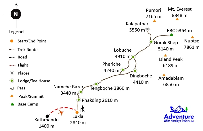
The classic Everest Base Camp trek starts from Lukla (2,860m) and ends at the base camp itself (5,364m). The total round trip is around 130 kilometers (81 miles). Most trekkers take 12 to 14 days to complete it, including time for acclimatization. The trek passes through famous places like Namche Bazaar, Tengboche, Dingboche, and Gorak Shep.
The Everest Base Camp map shows a steady climb through beautiful Sherpa villages, river valleys, suspension bridges, and rhododendron forests. It also highlights the main viewpoints like Kala Patthar (5,545m), which offers one of the best views of Everest.
Key Stops on the Map
1. Lukla to Phakding (2,610m)
This is your first day on the trail. The map shows a short, downhill walk that takes around 3–4 hours. It’s a gentle start to help you ease into the journey.
2. Phakding to Namche Bazaar (3,440m)
This is one of the tougher climbs early in the trek. The trail follows the Dudh Koshi River and crosses several high suspension bridges. Namche is the biggest town in the region and a great place to rest.
3. Namche to Tengboche (3,860m)
On the map, this section looks like a zigzag. That’s because of the ups and downs. Tengboche is home to the famous monastery, and the views of Ama Dablam here are unforgettable.
4. Tengboche to Dingboche (4,410m)
This is where the air gets thinner. The map shows the trail entering more open, alpine terrain. You’ll feel the altitude here, so slow, steady walking is key.
5. Dingboche to Lobuche (4,940m)
This part of the map passes through the quiet village of Dughla and the memorial area for climbers who lost their lives on Everest. It’s a moving place that adds depth to the journey.
6. Lobuche to Gorak Shep and Everest Base Camp (5,364m)
The final push. You’ll reach Gorak Shep first, then hike to base camp and return to Gorak Shep for the night. The terrain is rocky and dramatic. Even though you can't see the Everest summit from base camp, standing there is a wild feeling.
What the Map Doesn’t Tell You
Maps show the path, but not the feeling. They don’t tell you how your heart races when you first spot Everest. They don’t show the kindness of the teahouse owners or the laughter around the stove in the cold evenings. The Everest Base Camp map is a helpful tool, but the real story happens when you walk it.
It also won’t warn you about the “yak jam” that can stop your hike for 10 minutes or the trail snacks that become your secret comfort. I’ll always remember the sharp smell of juniper burning in the villages and the crisp sound of ice underfoot near Gorak Shep. One unique word I’d use to describe the whole experience? Soulprint—because the trail leaves a deep mark on who you are.
Final Thoughts
Using the Everest Base Camp map was one of the best ways to prepare for the trek. It helped me plan, set daily goals, and understand how to pace myself. But more than that, it gave me a bird’s-eye view of a life-changing journey. If you’re thinking about this trek, take time to study the map—but don’t be surprised when the real adventure turns out even better than the paper version.
Every step you take on that trail is more than just distance covered. It’s a story, a challenge, and a memory in the making.