Ground Penetrating Radar Role In Geotechnical Exploration
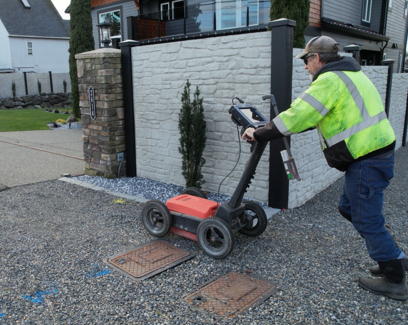
Ground Penetrating Radar is a non-destructive geophysical technique that uses electromagnetic waves to detect and map subsurface features and structures. It has a wide range of applications in geotechnical investigations, including soil and rock characterization, mapping subsurface structures, and identifying potential hazards. GPR works by transmitting a high-frequency electromagnetic pulse into the ground, which is then reflected by a receiver by subsurface features with different dielectric properties. The time delay and amplitude of these reflections are used to create a 2D or 3D image of the subsurface.
One of the most significant benefits of GPR is its ability to provide high-resolution images of subsurface features, with the potential to detect features as small as a few centimeters. GPR can be used to identify buried structures such as pipes, cables, and foundations and map the thickness and composition of subsurface layers. In geotechnical investigations, GPR can be used to assess the stability of soil and rock formations, identify potential hazards such as sinkholes or subsurface voids, and evaluate the condition of existing infrastructure.
How Ground Penetrating Radar Enhances Geotechnical Assessments?
GPR is a versatile and powerful tool for geotechnical investigations, with applications in a wide range of industries, including construction, mining, and environmental remediation. Ground penetrating radar concrete can provide valuable insights into subsurface conditions, allowing for proactive measures to be taken to mitigate risks and prevent damages. However, it is necessary to note that GPR is just one of many geophysical techniques available for subsurface investigation and should be used in conjunction with other methods for a comprehensive assessment of subsurface conditions. Scroll down to explore more roles!
Soil And Rock Characterization
GPR can be used to determine the thickness and composition of soil and rock layers beneath the surface. GPR works by casting electromagnetic waves into the ground and measuring the time it takes for the waves to bounce back from different layers of subsurface material. By analyzing these measurements, geotechnical engineers can determine the depth and composition of subsurface materials, which is useful for understanding the geology of a site and identifying potential risks such as unstable soil or rock formations.
Mapping Subsurface Structures
Ground penetrating radar is commonly used to map the locations and depths of underground structures such as foundations, pipes, and cables. GPR can detect changes in the subsurface material caused by the presence of these structures, allowing geotechnical engineers to create a detailed map of their locations and depths. This information is valuable for planning construction projects and avoiding damage to existing infrastructure.
Site Selection And Evaluation
GPR can help geotechnical engineers evaluate potential sites for construction projects. For example, GPR can be used to determine the depth and properties of bedrock, which can impact the feasibility of constructing buildings or bridges. GPR can also be used to assess the risk of subsurface hazards such as sinkholes or unstable soil, which is necessary for determining the suitability of a site for construction.
Soil Moisture Content Determination
GPR can be used to measure the moisture content of soils, which is useful for predicting the effects of precipitation on slope stability or for monitoring moisture levels in earthworks. Ground penetrating radar works by casting electromagnetic waves into the ground, and the amount of moisture in the soil affects how quickly the waves bounce back. By analyzing these measurements, geotechnical engineers can determine the moisture content of the soil and make informed decisions about how to manage the site.
Locating Buried Objects
GPR commonly locates buried objects such as underground storage tanks or buried debris. GPR can detect changes in the subsurface material caused by the presence of these objects, allowing geotechnical engineers to create a detailed map of their locations and depths. This information is valuable for planning excavation or construction work and avoiding damage to existing infrastructure.
Determining Pavement Thickness
GPR can be used to determine the thickness of various pavement layers, including asphalt, concrete, and base materials. It can be useful for evaluating the condition of roads and runways, identifying areas of deterioration or damage, and planning maintenance or repair work. Ground penetrating radar contractor
can also provide information on the subgrade soil beneath the pavement, which can help identify potential issues with soil compaction, drainage, or settlement.
Detecting Subsurface Voids
GPR can detect voids or cavities in subsurface soil or rock, indicating potential risks to construction projects or infrastructure. Void detection can be useful for identifying areas where sinkholes may form or for assessing the stability of foundations or retaining walls. Ground penetrating radar can also be used to investigate the cause of voids, such as the collapse of underground structures or soil erosion due to groundwater flow.
Investigating Sinkholes
GPR can be used to investigate sinkholes, including mapping the size and depth of the sinkhole and identifying any underlying causes, such as subsurface voids or fractures. GPR can help identify areas where sinkholes may form, allowing for proactive measures to be taken to prevent damage to infrastructure or property.
Evaluating The Condition Of Structures
GPR can be used to evaluate the condition of existing structures, such as bridges or retaining walls, by assessing the thickness and condition of the subsurface materials. GPR can detect issues such as corrosion, cracking, delamination in concrete, or degradation of steel reinforcement. This information can be used to identify areas that require repair or maintenance or to assess the structure’s overall condition.
Monitoring Changes Over Time
GPR can be used to monitor changes in subsurface conditions over time, such as the effects of natural phenomena like erosion or subsidence or the impact of construction or development activities. By comparing GPR scans taken at different points in time, changes in subsurface conditions can be identified and analyzed, allowing for proactive measures to be taken to prevent damage or mitigate risks. It can be particularly useful for monitoring the stability of slopes or embankments or assessing the impact of construction activities on nearby structures or infrastructure.
Avail Of The Best Services For The Accurate Results!
C-N-I Locates, a reliable provider of a wide range of services designed to meet the needs of industries such as construction, utilities, and more. Their service offerings include aerial drone imagery, concrete and structural imaging, electrical ground fault locating, ground penetrating radar, leak detection, magnetic detection, metallic line detection, non-metallic pipe detection, plastic water locates, private utility locates, utility mapping, video camera pipe inspection.
With a commitment to accuracy and precision, C-N-I Locates is dedicated to providing its clients with the best possible service experience. Whether you require underground utility mapping, leak detection, or aerial drone imagery, their team of skilled professionals utilizes the latest technologies to deliver reliable and accurate results.
By availing of C-N-I Locates’ services, you can rest assured that your project is in safe hands. Their expertise and state-of-the-art equipment enable them to deliver superior results, helping you save time and money in the long run. If you’re looking for reliable and accurate ground penetrating radar concrete services, C-N-I Locates is undoubtedly a name you can trust.